June 2023, Vol. 250, No. 6
Features
Detecting Leaks Using Remote Sensing Pipeline Monitoring
By Grant Wiseman, Remote Sensing Technology Manager, Stantec Consulting Ltd.
(P&GJ) — Pipelines are incredibly valuable assets for the energy and resources industry. Not only are they the safest way to move petroleum and other products, but they are also the most cost-effective and sustainable option to do so.
Just think about it. Pipelines can carry hundreds of thousands of barrels of petroleum products per day. Imagine that same amount being transported on our roads or rails, and the abundant greenhouse gas (GHG) emissions that would come with using that approach. It’ll make your head spin.
Pipelines are here to stay, at least for the near future. After all, we won’t be able to build our clean energy future over night. It will take time, and pipelines can help get us there in a safer and more sustainable way. But pipeline projects often face stiff opposition from environmental groups which may instead focus on the possibility of leaks and the potential damage these leaks could do to the environment.
We know that leaks do occur, and they can happen for a variety of reasons. These can include issues of ground movement, corrosion, or operational failure. When these kinds of events happen, they can have significant negative effects on the environment, wildlife, and local communities. But they can also have profound consequences for pipeline operators, such as the cost of lost product, the cost of the clean up, and the hit to their public reputation.
To make pipeline projects more viable in the larger public eye, operators need to convince stakeholders that should a leak ever occur, it will be repaired as soon as possible – with minimal impacts to the environment. One way to achieve this is through remote sensing technology, which gives operators the ability to monitor pipelines in near real-time.
So, lets explore what remote sensing is, how it’s been revolutionized over the years, and how it can help monitor pipelines for leaks using satellite imagery from space.
Brief History
Our approach to monitoring pipelines has certainly evolved over the years. Historically, pipeline operators would physically tread along the pipeline route looking for signs of a potential leak. This approach would evolve with the use of planes (with pilots trained to visually identify leaks), and eventually to using unmanned drones. While these methods helped to detect leaks, they were not necessarily cost- or time-effective.
For many new pipeline projects, these efforts are no longer necessary. Why? Because new pipelines utilize fiber optics and computational monitoring systems that inform operators of leaks.
However, these technologies are often not available for older pipelines buried in the ground, as they are extremely difficult – and costly – to retrofit. That is where remote sensing comes into play.
Remote sensing specialists capture and analyze images that are taken from above the surface of the Earth. This enables a deeper understanding of our planet and how it changes over time. In recent years, we have relied on satellites to provide images continuously throughout the day.
This approach to imagery provides near real-time data and helps us make more informed decisions about anything related to Earth’s surface. For the energy and resources industry, we can use this satellite imagery to monitor pipeline infrastructure for leaks.
It's clear that remote sensing technology can help operators find leaks faster –and cheaper – than conventional methods. But how does it work?
Remote Sensing
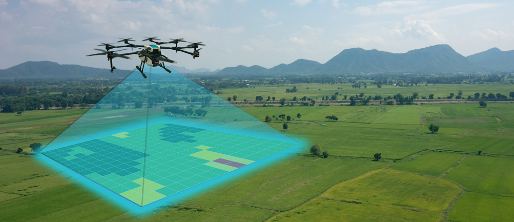
In the past few years, remote sensing technology has evolved significantly. Before, the satellites used to capture these images were large – about the size of a large truck or trailer – and expensive. But now we use dove satellites. These small satellites are about the size of a microwave and significantly less costly to manufacture or launch. When launched in a constellation, these small dove satellites work in coordination to achieve complete coverage of the earth at all times of the day.
These advancements in technology have enabled our teams to create a suite of tools that help our clients in many ways, from monitoring landslides to wildfires to sediment in the ocean floor. But we also use it to effectively monitor buried pipelines. We call this tool PipeWATCH, and it can help pipeline operators not only know where a leak occurs, but when.
How does it work? Our remote sensing teams collect images from the dove satellites – they use RBG (red, blue, green) images and examine them alongside near-infrared images. This enables us to monitor vegetation that is growing above and around buried pipeline infrastructure. Combined, these images can give us detailed information about the health and vigor of any vegetation on the earth’s surface.
We can then calculate sensitive vegetation health measurements on the pipeline right-of-way (ROW). Using change-detection analysis, we compare ROW vegetation health values from one day to the next, looking for signs of reduced vegetation health. A decline in vegetation health on a pipeline ROW could be caused by a release event. But when we notice a change to the vegetation, we know that a leak may have occurred.
As you can see, our remote sensing teams can no longer just see the where, they see the when. And they can see it in near real-time. That is real value from remote sensing specialists that all stakeholders of pipeline projects can and should appreciate.
Technology in Action
Using remote sensing technology to detect pipeline leaks more quickly is a great thing for the energy and resources industry. The earlier you catch a release, the greater the environmental and economic benefit. And catching a spill faster can reduce your rehabilitation costs and minimize negative publicity.
But the technology gives us the ability to look back in time as well. How? All the imagery captured by the dove satellites each day is stored and banked for historical knowledge. This allows our teams to go back and retroactively look at the images to get a sense of how a change has occurred over time. In fact, we’ve even used these tools to show potential clients how they could have acted on a leak sooner if they had employed remote sensing technology.
For example, a potential client reached out to our teams and expressed an interest in using PipeWATCH for their pipeline project. However, they were skeptical of the technology and wanted to see it put into real-life practice before committing to it. So, our teams performed a proof-of-concept study to demonstrate the power of our remote sensing team.
The client had experienced a pipeline leak the year prior, and they wanted to see if we would have been able to detect it with the dove satellites. They told us that the leak occurred somewhere within an area larger than 600km2 (approximately 231 square miles). That’s all the information they gave to our teams – no prior historical data, no infrastructure, no right-of-way data. We had to determine the rest.
They asked us to review the data from a four-month window and see if we could determine exactly when and where the spill had occurred – and if we could identify it before they had. By analyzing the satellite images and running the highly sensitive vegetation change detection analysis, we determined the location of the release and when it started. Our client verified that we had found the correct site. The kicker? They also admitted that our remote sensing technology discovered the leak five days before they found it!
Had this client embraced remote sensing technology prior to this leak, they could have caught the release five days earlier and perhaps saved millions of dollars in lost production and clean-up costs.
Gamechanger
Pipelines will be a part of our energy infrastructure for the foreseeable future. Even if society were able to completely rid itself of fossil fuels, pipelines would still be needed to transport other forms of energy – such as hydrogen or biofuels – and captured carbon.
As we said earlier, not only are pipelines the safest way to move these products but they are also the most sustainable way of doing so.
If we understand that pipelines will continue to be a key part of our infrastructure, then we must find a way to manage them in the most effective way. Remote sensing technology can offer this to pipeline operators around the world, providing them with a means of detecting leaks in near real-time and giving them a deeper understanding of their assets.
Many new pipelines won’t require this tool, but there are thousands of miles of buried pipelines that will. And by employing remote sensing experts, those pipeline operators can rest easier knowing they have the knowledge to protect the environment and surrounding communities from the impacts of a potential leak.
Comments