March 2024, Vol. 251, No. 3
Features
Using Integrated Approach Toward Geohazard Threat Management
By Rhett Dotson, Chief Engineer, D2 Integrity, and Alexander McKenzie-Johnson, Senior Principal Engineering Geologist, Geosyntec Consultants
(P&GJ) — In a recent advisory bulletin (ADB-2022-01, Potential for Damage to Pipeline Facilities Caused by Earth Movement and Other Geological Hazards), PHMSA highlighted the importance of proactive integrity management, to reduce the potential for damage to pipeline facilities caused by earth movement or other geological hazards, collectively referred to as “geohazards.”
The bulletin is part of the increased interest by regulators in proactively managing geohazards, pipeline companies and the public. The bulletin also demonstrates some of the increased awareness of how these threats can be identified, assessed and ultimately managed prior to an incident.
The good news is that geohazards are almost always identifiable and recognizable prior to an incident — using the right approach and using integrated data for a complete picture.
Geohazards can also be effectively managed through a combination of monitoring and mitigation efforts. In this article, we’ll discuss geohazards threats, the unique challenges associated with geohazards, the key considerations for building a geohazard management program and where the industry should concentrate efforts, so we — as an industry — are able to find the geohazards before the geohazards find us.
Intro to Geohazards
In discussing geohazards, we have to first define what we mean by the term “geohazard.” In the context of the PHMSA bulletin, a geohazard can be defined as a naturally occurring phenomena or human-trigged phenomena that occurs — similar to natural phenomena that results in the displacement of soil or rock.
Geohazards include landslides, seismicity, subsidence (such as from karst or collapse of underground mines), growth faults and other similar phenomena. In some instances, the action of rivers and streams is also considered a geohazard (also referred to as “hydrotechnical hazards”), but for this discussion, we will focus on those that result in earth movement.
An increase in awareness and an improvement in the capabilities of inspection technology have transformed how we view geohazards. A review of geohazard incident historical data from the PHMSA Significant Incident Database reveals that the rate of geohazard incidence does not appear to be increasing over the long-term; in other words, geohazard incidents were just as common in the 1980s and 1990s as they are in the 2010s and 2020s.
Still, the awareness around geohazards has changed, and technological improvements that allow for pipeline operators to proactively recognize and identify areas susceptible to geohazard occurrence prior to an incident. In other words, geohazard events are no longer “Acts of God” that cannot be predicted or addressed ahead of time.
Fortunately, these technological improvements — such as lidar and inertial measurement unit (IMU) bending strain — have allowed operators to identify and evaluate geohazards with far greater accuracy and precision than was previously possible. This, in turn, greatly improves the ability of operators to manage them.
How Geohazards Differ
Geohazard threats are inherently different than other types of integrity threats — like corrosion or cracks — because geohazards usually involve phenomena that not only extend outside of the pipeline but also often extend well outside of the ROW and, at the time of identification, may not even cross or intersect the ROW.
They also encompass a huge range of behavior, from earthquakes that can happen with no advanced warning, to landslides that can suddenly reactivate after years or decades of dormancy and which can move at speeds measured in miles per hour or continuously move or creep at rates as slow as inches per year.
Geohazards can be small and entirely confined to a pipeline ROW, or they can be large, with sizes measured in tens of miles. The approach to the management of geohazard needs to consider five basic principles:
- Geohazards occur where they have occurred before. In other words, to have the potential for a geohazard, the area must be susceptible to the occurrence of that geohazard, which means that the geohazard has likely already occurred in that area.
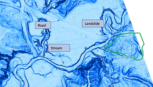
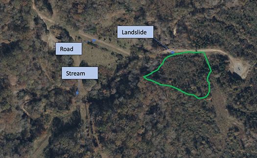
- Locations where geohazards are likely to occur can usually be identified. Geohazards usually leave evidence of their occurrence, such as disrupted and hummocky soils from past landslides. With the advent of lidar technology, past occurrences of geohazards — such as landslides, faults, and subsidence — can be reliably identified, even in areas of thick tree cover (see the example below).
- Most incidents can be avoided or mitigated preemptively. If locations susceptible to geohazards can be identified proactively, then this means that pipeline operators can take steps to reduce the potential that a geohazard will result in a pipeline incident.
- Geohazards occur in all states and provinces. As the lidar example below shows, landslides and other geohazards can occur in locations often not widely considered to be landslide-prone, such as Mississippi. No locations should be assumed to not have exposure to geohazards without first performing at least a desktop-level assessment, to evaluate geohazard susceptibility.
- The timing of geohazard incidents can usually not be predicted. The most obvious example is earthquakes, which cannot be forecasted with current technology. Other examples are landslides, which might increase in rate of movement, decrease in rate of movement, or suddenly become active after long periods with no activity; or subsidence, where sinkholes may form with little advance warning. This means that geohazard management programs need to account for these unpredictable factors and cannot assume that current behavior will continue indefinitely into the future.
It is important to remember that there are often considerable uncertainties associated with geohazards, such as those discussed above. Geohazard management programs need to have appropriate conservatism and measures in place to account for and manage these uncertainties. It should also be remembered that with rare exceptions, most pipelines — even newer pipelines built in the 2000s — were not designed to accommodate the effects of geohazards, and thus, all pipelines (of any vintage) can be potentially affected by geohazards.
Threat Management
The integration of geohazards as part of a formal component of pipeline integrity programs is relatively recent, with most pipeline operator’s pipeline geohazard management programs dating only from the 2010s and 2020s.
The field of pipeline geohazard management can be considered developmental, and at this time, it has few prescriptive regulations or agreed-upon industry standards. Thus, it is up to each operator to set the requirements and structure for their geohazard management program.
To assist the operator in this process, the Interstate Natural Gas Association of America (INGAA) Foundation has released multiple sets of guidelines, including “Management of Landslide Hazards for Pipelines”1 and “Framework for Geohazard Management”2.
As described in “Framework for Geohazard Management,” operators are recommended to identify and assess geohazards using a three-level framework, progressing from an initial assessment (i.e., Level 1) conducted at desktop level for entire pipeline systems, to a highly detailed, site-specific assessment (i.e., Level 3).
Typically, the length of pipeline or number of sites being assessed decreases with each increasing level of assessment. The Level 1 Geohazard Assessment can be considered a screening-level assessment, used to preliminarily identify areas susceptible to geohazard occurrence and to target areas for the more detailed Level 2 and Level 3 assessments as needed.
The Level 1 Assessment is most reliable when conducted using an integrated combination of IMU bending strain, geomorphic assessment from lidar, and prior geologic and hazard mapping from public agencies.
By integrating these multiple datasets, the pipeline operator can perform complimentary assessments to identify areas potentially susceptible to geohazard occurrence, and they can also evaluate if the geohazard(s) may have already impacted a pipeline and the degree of that impact (such as evaluating if a landslide that crosses a pipeline centerline may have resulted in pipe strain).
While these tools can be used independently (i.e., only lidar or only IMU bending strain), doing so can create gaps in the identification and assessment of geohazards, which can increase the likelihood of geohazards not being proactively recognized and addressed.
Where to Start
For the pipeline operator without a current in-house geohazard management program or a relatively immature program, it can be daunting to know where to start. The INGAA Foundation’s “Framework for Geohazard Management” provides some good advice on this subject. These recommendations can be summarized as follows:
Identify someone to manage geohazards. Ideally, this would be an employee or team inside the pipeline operator’s pipeline integrity department, but this can also be an external contractor, if the operator does not have the resources to staff it internally.
Establish a preliminary process for Level 1 Assessment. This should include reviewing the availability of data within the pipeline operator, such as previously collected lidar and IMU bending strain, as well as past records or databases of prior geohazard incidents.
Operations staff should be consulted when starting a geohazard management program, as they will often be aware of past locations of landslides and other geohazards.
Establish how the data will be stored. Ideally, the data management system will be a Geographic Information Systems (GIS) database, such as the ESRI suite of ArcGIS products.
Conduct a pilot assessment. Use a pipe segment or system likely to have geohazards. The gold standard for conducting the Level 1 includes collecting lidar — specifically for the area being assessed — and performing an IMU bending strain assessment to reflect the current condition.
However, if lidar cannot be collected by the operator, there is an increasing availability of reasonable quality lidar maintained by the United States Geological Survey (USGS), although the data is of mixed resolution and age.
Similarly, if an IMU bending strain analysis cannot be performed specifically for the Level 1 Assessment, prior ILI runs may be analyzed (as long as IMU data was collected) for bending strain — even if the ILI run occurred several years previously.
Refine the assessment process. Also, establish classification and decision-making (CDM) criteria based on the lessons learned during the pilot.
Continue with the Level 1 assessment process. Do this for the remaining areas of the pipeline system, then proceed to Level 2 and 3 assessments at targeted locations, based on the results of the Level 1 assessment. Further refine these approaches and the CDM as needed.
Establish threat management approaches. These should be based on the results of the leveled assessment process.
Implement threat management measures. These will include monitoring and mitigation to manage the geohazard threat.
Transition the program to continue this cycle. Emphasize monitoring, reassessment and response going forward. Additional assets that are built, acquired or constructed should also be subjected to this process, too.
Integrated Approach
As a closing thought, operators are recommended to have a comprehensive geohazard program that integrates information about the pipe condition and information about the geological landscape. Both types of data are required for a complete picture.
While IMU data might provide information on the impact to a pipeline from a geohazard, it does not provide information on threats that may not currently impact the pipeline but have the potential to do so. Similarly, lidar may not be able to identify sites that have been historically regraded or repaired, and it is not a reliable tool to evaluate past impacts to a pipeline from a geohazard.
Ideally, using an approach with integrated data provides operators with the most robust and reliable approach to prioritize threats and reduce their exposure to geohazards.
As a final note for those operators with more mature or established geohazard programs, combating complacency will be key. Staying involved with pipeline industry forums and conferences and contributing to research will be vital to the continuous improvement of these programs.
Authors: Rhett Dotson is chief engineer at D2 Integrity, a pipeline integrity management consulting firm. With over 18 years of experience in the pipeline industry, he has used his expertise to transform data collected from in-line inspection, analysis, and full-scale testing to manage threats associated with mechanical damage, geohazards, and vintage pipe materials.
Alexander McKenzie-Johnson is senior principal engineering geologist at Geosyntec Consultants. He specializes in geohazard management and has 22 years of experience, primarily as a consulting geologist, with additional time spent implementing and running operations for a geohazard management program for a large pipeline operator.

Comments